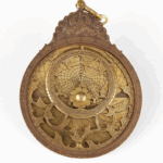
Mariner’s Astrolabe
Tool
Age of Discovery
Quick Facts:
One of the oldest of all the altitude measuring devices, the astrolabe is an angle-measuring tool. Its name comes from the Greek, “to take a star.”
Introduction
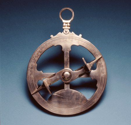
The mariner’s astrolabe was an navigation tool used for taking the altitude of the sun or stars while at sea. Its history dates as far back as the Ancient Period and into Medieval Period. Its name means “to take a star” or “star taker.” The mariner’s astrolabe was the preferred instrument for more than 200 years. Sailors such as Columbus and Magellan relied on this tool during their journeys across the oceans.1
History
The mariner’s astrolabe was an important navigational tool for finding latitude. It is a simplified version of the traditional astrolabe – an instrument that could help tell time, find altitude, and find latitude. The mariner’s astrolabe measures the height of the sun or a star above the horizon. Used with star and planetary charts and tables, the observer can find their latitude. Astrolabe history begins in ancient Greece. Many scholars credit Hipparchus, an ancient Greek astronomer and mathematician, with the invention of the astrolabe.2 The first major writer on the description and construction of astrolabes was ancient astronomer Claudius Ptolemy. He gave much detail about the earliest uses of the instrument it in his writings called Planisphaerium. Although ancient Greek astronomers developed a version of the astrolabe, the instrument was highly developed and used extensively in the Islamic world by the 9th century.3 The astrolabe was very valuable in the Islamic religion. It helped determine the astronomically defined prayer times, and was an aid in finding the direction to Mecca – Islam’s holiest city. In its earliest use, the astrolabe was used some for travel over land, for astronomy – the study of the stars – and for telling time, but not necessarily for water navigation. These were planispheric astrolabes. These astrolabe was introduced to Europe from Islamic Spain (al-Andalus) around the early 12th century.
As mentioned, early astrolabes were typically used for land journeys. As Europeans began traveling farther distances across seas and oceans, they created a version of the astrolabe for maritime travel. Thus, the mariners’ astrolabe was born. It became widely used in Europe in the late Middle Ages and Renaissance, peaking in popularity in the 15th and 16th centuries. A knowledge of astronomy was considered to be fundamental in education. We know today that almost one-third of all known astrolabes were made in Portugal during the 16th and 17th centuries.4 For several centuries, the astrolabe was considered one of the basic astronomical education tools. The early instruments were made of brass or wood. Mariner’s astrolabes would typically be made of brass or iron. This made them heavy but sturdy. Better for use on moving vessels, which allowed for more accurate measurements of latitude. They ranged in size: some as small as 4 inches in diameter to some as large as 24 inches in diameter. In early navigation days, sailors could not determine longitude, but did know how to find latitude. By knowing this, navigators could find the latitude line and sail east or west along it to reach their destination. The mariner’s astrolabe was very useful for this task. Despite being a useful tool, the mariner’s astrolabe had its problems. It was not always an accurate tool at sea because it is difficult to keep it steady on a rolling ship and in high winds. This could result in degree errors that may throw a ship off course. The mariner’s astrolabe remained the most popular astronomical instrument until the end of the seventeenth century. It became replaced by more accurate instruments such as quadrants and sextants.5
How It Works
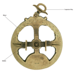
The mariner’s astrolabe measures the angle between a star and the horizon. Generally, sailors would measure the angle using the sun during the day, and Polaris (the north star) at night. There are several key parts to the mariner’s astrolabe. The ring at the top is what the navigator would hold to suspend or dangle the astrolabe. The alidade contained two small holes which the user would use to sight the sun or star. And the wheel which displayed a degree scale. So how does it work?
Measurements during the day would be taken using the noon sun. To correctly measure the angle, the astrolabe must hang down so that it is perpendicular (⊥) to the ocean. Next, the navigator uses the alidade to line up the two holes so that the sun’s rays come through both holes. The navigator then reads the angle measurement from the scale around the circumference of the astrolabe. The alidade would indicate the sun’s altitude on the degree scale. This angle would be compared to star charts and tables, the altitude could be used to determine latitude.6 Measurements at night were used differently. Stars were observed by holding the instrument up to the eye. The user would line the pinholes of the alidade so that they could see the star through both holes. The alidade would indicate the altitude on the degree scale. This angle would be compared to star charts and tables, the altitude could be used to determine latitude.7 To learn more, watch the short video under the Resources tab on how a mariners’ astrolabe works.
Endnotes
- Peter Ifland, Taking the Stars: Celestial Navigation from Argonauts to Astronauts (Malabar: Krieger Publishing Company, 1998), 7.
- Timothy M. Kusky and Katherine E. Cullen, Encyclopedia of Earth and Space Science (New York: Facts on File, Inc., 2010), 375 – 376.
- Gerard L’E Turner, Scientific Instruments 1500 – 1900: An Introduction (London: Philip Wilson Publishers, 1998), 13.
- Peter Ifland, Taking the Stars, 6.
- Helaine Selin, ed., Encyclopaedia of the History of Science, Technology, and Medicine in Non-Western Cultures (Dordrecht, The Netherlands: Kluwer Academic Publishers, 1997), 75.
- Robert Bud and Deborah Jean Warner, eds., Instruments of Science: An Historical Encyclopedia (London: Taylor & Francis Group, 1998), 36.
- Robert Bud and Deborah Jean Warner, eds., Instruments of Science, 36.
Bibliography
Bud, Robert and Deborah Jean Warner, eds. Instruments of Science: An Historical Encyclopedia. London: Taylor & Francis Group, 1998.
Ifland, Peter. Taking the Stars: Celestial Navigation from Argonauts to Astronauts. Malabar: Krieger Publishing Company, 1998.
Kusky, Timothy M.and Katherine E. Cullen. Encyclopedia of Earth and Space Science. New York: Facts on File, Inc., 2010.
L’E Turner, Gerard. Scientific Instruments 1500 – 1900: An Introduction. London: Philip Wilson Publishers, 1998.
Selin,Helaine, ed. Encyclopaedia of the History of Science, Technology, and Medicine in Non-Western Cultures. Dordrecht, The Netherlands: Kluwer Academic Publishers, 1997.
Gallery

