Quadrant
Tool
Age of Discovery
Quick Facts:
Used at sea as early as the mid 1400s, the quadrant was used by sailors to measure the height of Polaris, the Pole star.
The quadrant received its name because it is one-fourth of a full circle. In fact, quad means “four.” It had much use even before it went to sea to help navigators.
Astrologers would use the quadrant to help determine an eclipse of the sun or to forecast someone’s fate with help from the stars. It was simply a device for measuring the angular height of a star or the sun. Surveyors could use it to measure the height of a building or a mountain. It was even used to help aim a cannon to hit an enemy fortress.
For the sailor, it was first used to measure the height of Polaris, the Pole star. While the earliest documented (written) use of the quadrant at sea is in the mid 1400s, it was in use well before that by astrologers and land-surveyors. It became important to Europeans when the Age of Exploration began in the early 1400s.
Everyone knew that the pole star moved very little at night because it sits at the North Pole. They knew it wasn’t exactly at the North Pole, but pretty close. In fact it’s about one degree away from being exactly at the North Pole today, and was about 3 1/2 degrees off in the time of Christopher Columbus. People knew these things, but didn’t have any practical use for the information ashore.
Sailors had learned from the Arabs that the Pole Star could also help with navigation; the height of Polaris above the horizon changed depending on a person’s Latitude, the distance above or below the equator. Knowing how high Polaris was at a particular port city you wanted to reach would help you navigate your way there.
The Arabs traded along the east coast of Africa, north and south, and had to go offshore, out of sight of land, because of dangerous shoals (shallow water) and currents. They couldn’t see their port cities. So they sailed until Polaris was the right height, and then turned toward the shore to reach their destination. Until the “Age of Exploration,” Europeans traded close to well known coasts going north or south, or they traded along the east-west routes of the Mediterranean. They didn’t need to know latitude. Once they began to travel into unknown waters off West Africa, the need for the Pole Star and determining latitude became important.
Of course, one of the problems with Polaris is that it disappears if you travel below the equator. The solution was to then navigate using the sun to determine latitude.
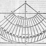
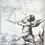
The quadrant is simple to use. Sight the star, or sun, along one edge, the right edge in the diagram. The piece of rope hangs down because of the weight attached (called a plumb bob), and the scale crossed by the rope gives the angular height of the body. With that information, you can obtain your latitude.
Of course, sighting a star is pretty easy on your eyes. But using the sun can be a problem because it’s so bright it may blind you. In fact, blindness and poor sight was a job hazard of early navigators. For more information, see the discussion of the Back-Staff.
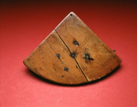
- Quadrant, circa 1650, Peter Ifland Collection, The Mariners’ Museum, (1998.39.10).
- Quadrant Diagram, La Geografia di Clavdio Ptolemeo, 1548, From The Library at The Mariners’ Museum, G87.P9.m4.1548 rare
- Quadrant, A New Collection of Voyages, Discoveries and Travels: Containing Whatever is Worthy of Notice in Europe, Asia, Africa, and America, 1767, From The Library at The Mariners’ Museum, G160.K75 rare.

